Liberty, Maine weather data for...
March, 2025
Season snowfall amounts:
(Chronological order)
'98-'99 78.65"
'99-'00 64.90"
'00-'01 126.98"
'01-'02 85.15"
'02-'03 74.00"
'03-'04 78.75"
'04-'05 44.77"
'05-'06 50.35"
'06-'07 82.65"
'07-'08 135.90"
'08-'09 90.25"
'09-'10 78.45"
'10-'11 125.10"
’11-’12 68.70"
’12-’13 100.70"
’13-’14 82.95"
'14-'15 148.25"
’15-’16 50.10"
’16-’17 93.65 "
’17-’18 108.15"
’18-’19 96.70"
’19-’20 73.85"
’20-’21 55.55"
’21-’22 64.45"
’22-’23 86.25"
’23-’24 60.60"
’24-’25 68.35"
Thru 4/12
26 season average: 84.89"


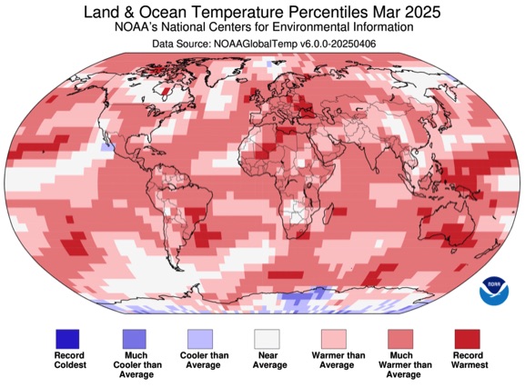
It looks like Rockland, Maine got the orange dot for 7-9 record highs.
Updated through 2024
Daily Data
High Temp 55.1° (3/22)
Low Temp 0.7° (3/3)
Top Rain Storm 1.63” (3/5-6)
Top Snow Storm 5.50” (3/24)
High Wind Gust 38 mph (3/6)
Low Wind Chill -7° (3/2)
High Dew Point 51.3° (3/17)
Low Dew Point -9.4° (3/2)
Barometer H/L 1025.3/981.4mb
Precipitation Days 15
2025 Averages
High Temp 42.36°
Low Temp 26.04°
Avg. Temp 34.20°
Precip. 3.93"
Snow 9.75”
High Wind Gust 19.94 mph
Humidity 69.50%
Dew Point 23.93°
Degree Days 954.75
Cooling Deg Days 0
Barometer 1008.87 mb
Red= record high since 1998
Blue= record low since 1998
Difference from 2024
High Temp +0.12°
Low Temp -3.12°
Avg. Temp -1.50°
Precip. -5.05”
Snow +3.00”
High Gust -0.51 mph
Humidity -5.19%
Dew Point -3.46°
Degree Days +46.45
Cooling Days 0
Barometer -2.67 mb
Precip Days -3
20 Year Avg.
High Temp 40.00°
Low Temp 23.89°
Avg. Temp 31.95°
Precip. 3.03”
Snow 15.72”
High Gust 22.46mph
Humidity 66.40%
Dew Point 20.39°
Degree Days 1025.43
Cooling Days 0.82
Barometer 1012.99
(avg 1998-2017)
2025 Vs. Average
High Temp +2.36°
Low Temp +2.15°
Avg. Temp +2.25°
Precip. +0.90”
Snow -5.97”
High Gust -2.52mph
Humidity +3.10%
Dew Point +3.54°
Degree Days -70.68
Cooling Days -0.82
Barometer -4.12mb
March notes:
Finally some daily records were broken. There were no records for high or low temps but March 30 set a record for coldest high temp when it reached only 31.0°. Three days set records for warmest low temps (3/5, 6 & 16)
Breakdown for month and year is 3 warm records and 1 cold record.
March was cooler than the last few but not to the point of going below average. Eight years into the third decade March is 2.13° warmer than the previous decade and 1.73° warmer than the first decade. (March was one of a few months cooler in the second decade than the first.)
March rankings (out of 28):
High Temp 9th
Low Temp 10th
Avg Temp 9th* (tie with 2006)
Precip 8th
Snow 19th
Wind 24th
Humidity 7th
Dew Point 6th
Heat Deg 20th
Cool Deg N/A *Only March 2016 registered any cooling degree days.
Barometer 23rd (out of 25)

12 Month Summary Index
Click month to view: